The Problem: As analyzed in Episode 1, the centralized Hub-and-Spoke telecommunications model is fundamentally flawed for disaster scenarios due to the Single Point of Failure (SPOF) at Base Transceiver Stations (BTS).
The Architectural Solution: We must shift to a Mesh Topology where network resilience is achieved through Self-healing and Multi-hop routing, eliminating reliance on a central coordinator.
The Implementation: We propose V-FloodNet, a Hybrid Architecture:
Rural Layer: Long-range LoRaWAN Mesh for lifeline connectivity in remote areas.
Protocol Optimization: Transition from heavy HTTP/TCP to lightweight MQTT-SN/UDP and implement Store-and-Forward mechanisms to handle intermittent connectivity.
1. Introduction: Beyond the "Offline Shock"
In Episode 1: System Failure Analysis, we conducted a "post-mortem" on the information infrastructure during the 2024-2025 disaster seasons. The conclusion was painful but necessary: We gambled our critical lifeline communications on antenna towers-the infrastructure most vulnerable to Category 4+ typhoons. When the BTS towers snapped or power grids failed, millions of modern smartphones became isolated silicon bricks.
Episode 2 tackles the most challenging engineering problem at the Physical Layer: How do we maintain digital connectivity when the national power grid and Internet backbone suffer a total blackout?
The answer does not lie in building stronger concrete towers (economically unfeasible), but in a fundamental Architectural Paradigm Shift: Moving from dependence on a central "Hub" to leveraging the collective power of "Edge" devices.
2. The Paradigm Shift: From Star to Mesh Topology
To build a Resilient System, we must ruthlessly eliminate Single Points of Failure (SPOF).
2.1. Technical Analysis of Topologies
Current Model: Star Topology (Hub-and-Spoke)Every client device connects directly to a central Router/BTS.
Pros: Centralized management, high throughput in ideal conditions, low latency.
Fatal Flaw: If the Central Node fails, the entire network collapses. There is no redundancy path.
Proposed Model: Mesh TopologyIn a Mesh network, the distinction between Client and Router blurs. Every device (Node) acts as a receiver, sender, and relay.
Mechanism: Data travels via Multi-hop Routing. If Node A wants to message Node Z but is out of range, the packet hops A $\rightarrow$ B $\rightarrow$ C $\rightarrow$ ... $\rightarrow$ Z.
Self-healing Capability: Routing protocols (like AODV, OLSR, or proprietary LoRa Mesh algorithms) continuously update the routing table. If Node B runs out of battery or is destroyed, the network automatically recalculates a new path via Node D or E.
Engineering Insight:"In a disaster context, network redundancy is not waste; it is the core requirement for survival."
Below is a visual comparison of how these topologies behave under stress:
Vietnam's topography is complex, ranging from dense urban centers (Hanoi, Ho Chi Minh City) to fragmented mountainous regions and vast river deltas. No single Mesh technology is a "silver bullet."
Datacore proposes V-FloodNet-a Hybrid Two-Tier Architecture optimized for specific contexts:
Datacore Digital Levees Vflood-net
Tier 1: Urban High-Density Mesh
Context: Urban flooding scenarios where population density is high, and inter-device distance is short (<100m).
Core Technology: Leveraging citizen smartphones as network nodes via Bluetooth Low Energy (BLE) or Wi-Fi Aware (NAN).
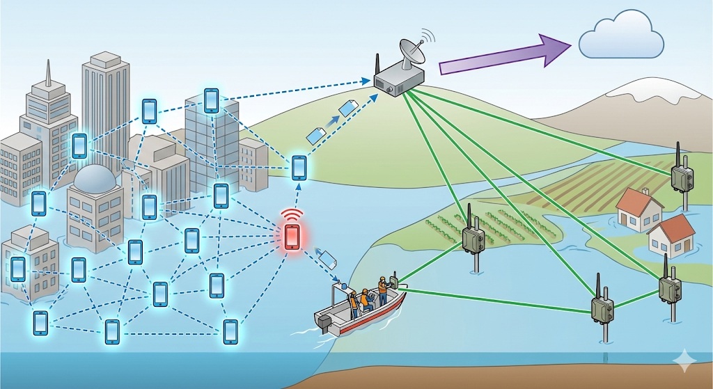
Principle: Turning every citizen into a "mobile base station." When thousands of people enable this mode, they create a massive connectivity cloud. An SOS message from a user trapped in a deep alley can "hop" through neighbors' phones, to a rescue boat's tablet, eventually reaching a device with an Internet uplink (e.g., a Starlink terminal).
Technical Challenges: OS Fragmentation (iOS and Android handle background Bluetooth advertising very differently) and battery drain.
Tier 2: Rural Long-Range Mesh
Context: Mountainous regions or flash flood zones where population is sparse. Distances between clusters range from 2km to 10km. Bluetooth is useless here.
Core Technology:LoRaWAN (Long Range Wide Area Network) operating on unlicensed bands (e.g., 433MHz or 923MHz in Vietnam).
Deployment: Equipping village heads, forest rangers, and rescue teams with low-cost, battery-powered LoRa Mesh nodes.
LoRa Technical Advantages:
High Link Budget (up to 168dB): Allows signals to penetrate obstacles and reach 10-15km in rural Line-of-Sight conditions.
Low Power Consumption: A node can operate for weeks on a single 18650 battery using Deep Sleep cycles.
4. Deep Dive: Protocol Optimization for Low Bandwidth
System engineers must be realistic: Mesh Networks, especially LoRa, have extremely low Throughput (ranging from a few hundred bps to a few kbps).
Warning:"Do not design for video streaming or high-res photos on a rescue Mesh. This is a Lifeline connection, reserved for the most essential bytes of data."
To ensure the network doesn't collapse under the load of thousands of SOS beacons, we must optimize at the Protocol Layer:
4.1. Replacing HTTP/TCP with MQTT-SN/UDP
Standard HTTP over TCP is too "heavy" (high overhead) due to the 3-way handshake and verbose headers.
Solution: Implement MQTT-SN (MQTT for Sensor Networks) over UDP. MQTT-SN is specifically designed for unstable, low-bandwidth environments, minimizing header size and connection establishment costs.
4.2. Extreme Data Compression
Avoid JSON text formats like {"lat": 21.0285, "long": 105.8542}. Instead, utilize Bit-packing or Binary Serialization standards like Protobuf or FlatBuffers.
A standard SOS packet should be compressed to under 50 bytes, containing:
Device_ID (4 bytes)
Timestamp (4 bytes)
GPS_Lat_Long (Compressed to 8 bytes)
Status_Code (1 byte - e.g., 1=Medical, 2=Food, 3=Critical Water Level)
Short_Message (Max 30 char text)
4.3. Store-and-Forward Mechanism
In storm conditions, Mesh connectivity is Intermittent. The system must adopt Delay-Tolerant Networking (DTN) principles.
If a Node receives a message but cannot find a path to the next hop, it must Store the packet in its local buffer and continuously Retry until a connection is restored or a new path is discovered (Forward). This guarantees that no cry for help is lost, even if delivery is delayed.
5. Real-World Benchmark: Lessons from Project Owl
This is not just theoretical engineering. After Hurricane Maria devastated Puerto Rico in 2017, leaving the island without power or comms for months, Project Owl (IBM Call for Code Winner) successfully deployed this exact model.
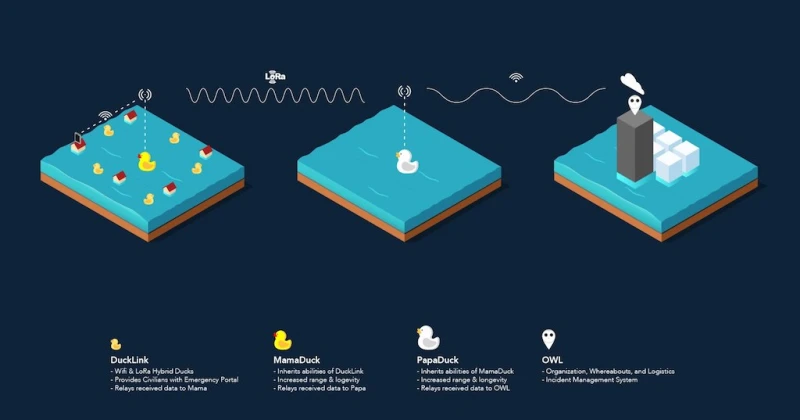
They utilized small, floating IoT devices called "DuckLinks" powered by solar panels. These DuckLinks automatically formed a Mesh, creating a "Captive Portal" for civilians to connect via Wi-Fi and send basic text SOS messages. These messages hopped through the DuckLink network until they reached a "MamaDuck" hub equipped with a satellite uplink.
Lesson: A simple, low-cost, Rapid Deployment Mesh network provides significantly higher practical value than expensive systems that rely on the survival of the national power grid.
Project Owl
Description: Small yellow "DuckLink" boxes floating in floodwaters among submerged houses, emitting signal waves. A person on a roof connects via phone. On a distant, dry hill, a larger "MamaDuck" unit with a satellite dish receives the aggregated data and pushes it to the cloud.
In Episode 2, we have solved the problem of "Building the Pipes." We have defined a decentralized infrastructure architecture capable of self-sustaining connectivity in worst-case scenarios.
However, restoring connectivity is only half the battle. When thousands of people simultaneously send SOS messages via the Mesh, command centers will face a new disaster: A DDoS attack of... rescue data.
How do we distinguish between a "Water is in my yard" message (Low Urgency) and a "Heart attack patient, water at chest level" message (Critical Urgency) amidst a sea of chaotic, unstructured, and noisy data?
The physical infrastructure needs a "Brain" to process this flow. This is where Big Data and Artificial Intelligence enter the equation.
COMING UP IN EPISODE 3: DATA & AI - TURNING CHAOS INTO SIGNAL.
We will deep dive into NLP models (like PhoBERT) for spam filtering, Computer Vision for water level measurement, and Data Fusion strategies to merge fragmented information sources.


One response to “DIGITAL LEVEES - EPISODE 2: Decentralize Infrastructure – Designing An "UNBREAKABLE" Survival Network”
[…] Episode 2: Decentralized Infrastructure, we successfully designed V-FloodNet – a resilient mesh network capable of maintaining baseline […]